Großglockner route and climbing map is available at My Places.
Apart from this, Rome, Praha, Portugal and Sicily trips have been reorganized
Sunday, February 25, 2007
Friday, February 23, 2007
My Places - the upgrade

Trying to utilize the new features provided by Google Maps, I have established a new standard to display the ALP summit log, the alpine info source at My Places.
In the latest version, apart from the pics and placemarks, You can find the tracklog of the path we used, along with a short summary of our experiences and recommendations. In case of climbing routes, there is a topo instead of the tracklog. Furthermore, there is an alpinistic map overlay to serve even more info about the territory. Currently, all these new features are available for our ascent on Mont Blanc, but the rest is coming soon.
In case of cycling routes, You can also find useful pieces of info as well as the elevation diagram of the route.
I needn't mention that this stuff is still embedded into a standard kml file, so in the future editions of Google Maps for Mobile You will most likely be able to find and display this info on the screen of your cell phone. And we have a good chance to enjoy GPS support, too :)
Wednesday, February 14, 2007
Google Maps searches private map info
Until now, You could search for locations and POIs (Point of Interest) using Google Maps. What's more, if You knew the address of a hosted kml or kmz file, You could use Google Maps to show its contents. But, You could not search for contents that others may have hosted. E.g., You might be looking for trekking pathes on a specific area, or touristic map overlays (like "crosscountry ski route nassfeld austria", etc). Altough others may have hosted such info (e.g. http://adszhu.googlepages.com), You just could not find them with Google Maps.
Google has just announced the change, and, as a first step, You can query for hosted geo contents from Google Earth. Find the original article here:
Google Maps API Official Blog: Search for KML in Google Earth
Google has just announced the change, and, as a first step, You can query for hosted geo contents from Google Earth. Find the original article here:
Google Maps API Official Blog: Search for KML in Google Earth
How many megapixels to go?
Almost every day there is new digicam announced, with the clear mission of providing more and more megapixels of resolution. But how many megapixels are useful for us? Is there an optimum? If so, is it avaliable yet? Let's start calculating!
Two things to take into consideration:
- The average human eye is only able to see two sperate points when they are seen under an agle larger than 1 arc minute (the 1/60th of a degree). Let's say the perfect human eye performes twice so good, by being able to separate two points under one half arc minute
- When watching pictures on a display that is 14' wide, the screen fills out the viewing angle of my eyes when watching from 33 cms. The viewing angle in this case is app. 56 degrees (from the top right corner to the bottom left)
How many pixels can I separate along the line from the top right corner to the bottom left? Approximately 56*60*2 = 6720. And what is the total resolution in this case? Come on, Pythagoras, let us know! In case of a picture ratio of 4:3, it is about 21 megapixels!!
So, the optimum is still not reached, there is still a reason why to increase resolution day by day.
--
Ádám
http://adszhu.googlepages.com
--
Ádám
http://adszhu.googlepages.com
Friday, February 9, 2007
Friday Morning Climbing
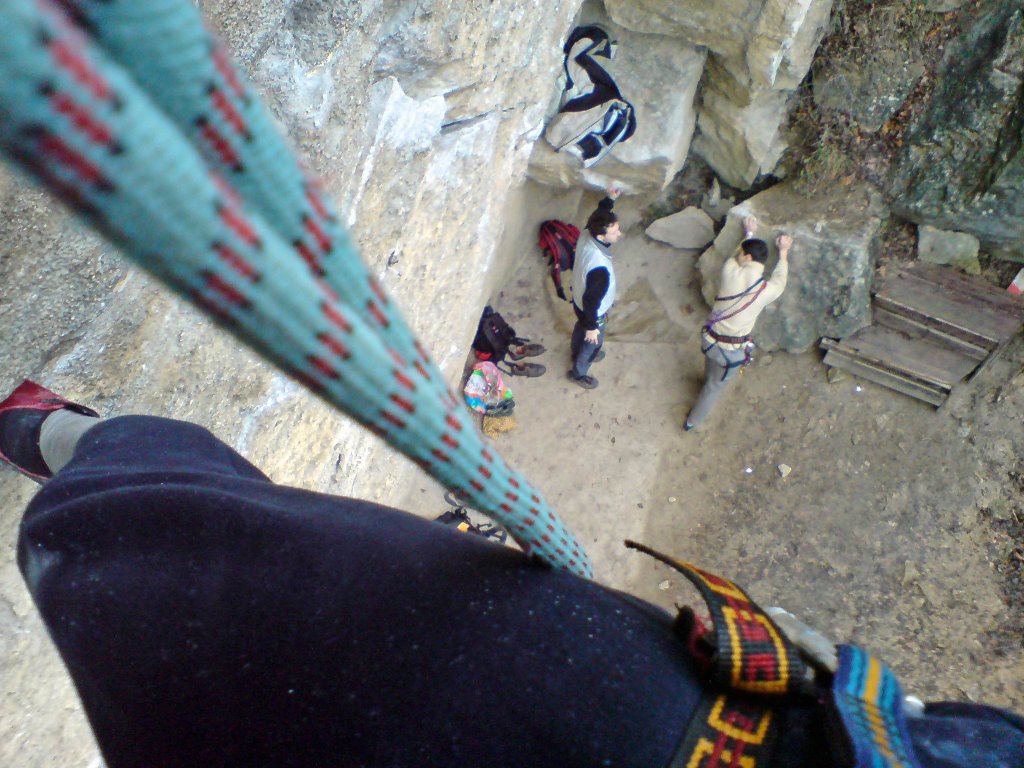


A couple of pics taken during our Friday Morning Climbs.
This is one of the most popular rock climbing places in Budapest, Hungary, called "Francia Bánya" . The route we used to train on is of difficulty VI+ (according to UIAA), app. 10 meters high, with a total overhang of about 1.5 meters. You can see how the rope is getting further from the wall.
The place is so much popular, that after the working hours it is always overcrowded. That is why we used to go either at 6:45 AM, or in the evening, when it is already dark.
Thursday, February 8, 2007
Apple iPhone - the mission
It has still not been declared. However, a couple of statements are onhand, encouraging me to go into assumption regarding the mission of this brand new and rather promicing mobile device.
Let's start with the features published by Mr. Jobs.
- Safari, the browser shipped with iPhone, though being not equivalent with the one running on desktop Macs, handles the Google Web Toolkit including Maps, Mail, Docs, Pages, Analytics, etc.
- OS X, the operating system is not equivalent with the one running on desktop Macs, thus only apps designed for iPhone will run on it
- Apple is not to let 3rd party developers produce applications for iPhone
- The Bluetooth module of iPhone seems to lack the serial profile, which is used to connect to GPS receivers
Considering all these aspects, I imagine the mission of Apple's iPhone as follows:
Instead of supplying separate applications to fulfill the usual palmtop requirements (office apps, mapping, etc), Apple provides a fullfeatured web browser to utilize the continuosly growing spectrum of web services. No applications and static data to buy and periodically upgrade, but a gateway to the internet to do your business there.
Regarding GPS, most likely You won't need any. The same philosophy just mentioned in connection with software seems to apply for hardware: it is the network provider who specifies the position on demand.
Naturally, it is nothing more than assumption. However, I would be satisfied with such a package of features
Ádám
Monday, February 5, 2007
Nassfeld tracklog
Find the tracklog of the dunhill on route No1 here.
Anyway, if You happen to look for a nice place to have smthg to eat in this region, visit the Gasthaus Schabus in Jenig. One of the highlights is Lissi, the turbo angel :)
Anyway, if You happen to look for a nice place to have smthg to eat in this region, visit the Gasthaus Schabus in Jenig. One of the highlights is Lissi, the turbo angel :)
Thursday, February 1, 2007
Bad Kleinkirchheim
For those of you fool for endless dunhills on broad, uncrouded routes, my recommendation is Bad Kleinkirchheim. If you plan to have a ski holiday in Kärnten, Austria, this region is a must. All routes descent about 1kms, and the No.8 is an extraordinary adventure. Find it here: http://maps.google.com/maps?q=Bad%20Kleinkirchheim,%20Austria
Ádám
Atomic SX7 review
Having tried both this model and its brother SX9, i feel comfortable saying it is a pretty good allrounder. Novices will most likely love it, as well as sporty amateurs like me. Don't worry to run into invisible fields, you are safe. However, if you concentrate on speedy turns on the edge, you had better go for SX9, which is somewhat harder. SX7, with a length of 166cm and a radius of 16m is just not keen on tight turns. You will feel a kind of slip to radial direction whenever you choose higher speed to a specific turning radius than it is designed for
Ádám
Subscribe to:
Posts (Atom)
About Me

- adszhu
- ADSZHU - that is my Windows login at my current workplace. Since the early 90's I periodically visit the "Playground of Europe" - the Alps as named by the first alpininsts. It is about getting as far from civilisation as possible, to face the original kinds of challanges presented by LIFE. The only thing I carry everywhere is my iPhone, so that I can trace my movements and access the Internet whenever I need it. My homepage is designed to publish as much info as possible for those of You with similar interest